 Project Britain
British Life and Culture
by Mandy Barrow
- Search our Site
- Project Britain
- Calendars
- Facts and figures
- London
- Great Britain
- Union Flag
- A-Z of Britain
- Customs & traditions
- Britain today
- Daily Life
- Money
- Etiquette
- Monarchy
- Government
- Education
- Tourist Information
- Food and drink
- Sports and leisure
- History
- Kings and Queens
- Superstitions
- Glossary
|
INTRODUCTION to Great Britain
|
|
|
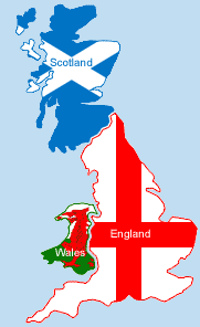
Great Britain (England, Scotland and Wales) is surrounded by seas on all sides and is separated from the European continent by the North Sea and the English Channel. It is just 1,000 kilometres from the south coast to the far north and just under 500 kilometres in the widest part. No place in Great Britain is more than 120 kilometres from the sea. Great Britain is one of the most densely populated countries of Europe, with the southern parts of the country reaching the highest density figures of Europe as a whole. The main mountain regions are the Cornish Heights, the Cambrian in Wales, the Cambrian Mountains (in Lake District) and the Pennies. The highest mountain in Great Britain is Ben Nevis in Scotland. There are many rivers in Great Britain. Among the most important rivers is the Thames, which flows into the North Sea. Its length is 336 km and it is the deepest rive in Britain. It is navigable as far as the capital of Great Britain – London. The longest river in Britain is the Severn. Its length is 354 km (220 miles). Other important rivers include the Trent, the Tay and the Tweed. ( Political map of Britain showing rivers and main towns and cities)
Questions about Great Britain Is Britain the same as Great Britain? Which countries are in Great Britain? |
|
 © Copyright - please read © Copyright - please read All the materials on these pages are free for homework and classroom use only. You may not redistribute, sell or place the content of this page on any other website or blog without written permission from the Mandy Barrow. |
© Copyright Mandy Barrow 2014
Mandy is the creator of the Woodlands Resources section of the Woodlands Junior website.
The two websites projectbritain.com and primaryhomeworkhelp.co.uk are the new homes for the Woodlands Resources.
Mandy left Woodlands in 2003 to work in Kent schools as an ICT Consultant.
She now teaches computers at The Granville School and St. John's Primary School in Sevenoaks Kent.
Woodlands Junior Homework Help new website

 The capital and largest city,